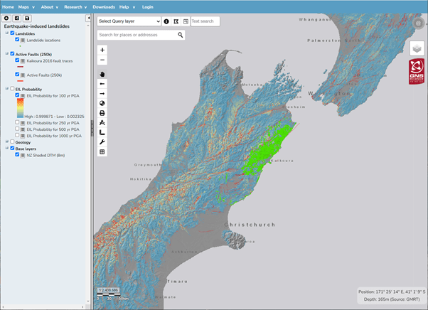
The EILD webmap (below) displays spatial data captured or derived from the project as it becomes available. Some data can be downloaded from the links provided
Currently the map has:
Earthquake-induced landslides (points only) generated by the M7.8 M 2016 Kaikoura Earthquake
Earthquake-induced forecast (probability) maps for 100-, 250-, 500- and 1000-year return period earthquake shaking for NZ.
Landslide Dams databse of NZ (points and polygons) including Dams and lakes formed behind them as well as the landsldie source and debris areas.
Massey CI, Lukovic B, Huso R, Buxton R, Potter SH. 2021. Earthquake-induced landslide forecast tool for New Zealand: version 2.0. Lower Hutt (NZ): GNS Science. 77 p. (GNS Science report; 2018/08). doi:10.21420/G2TP9V.
Massey, C. Townsend, D. Rosser, B. Morgenstern, R. Jones, K. Lukovic, B. Davidson, J. (2021) "Version 2.0 of the landslide inventory for the Mw 7.8 14 November 2016, Kaikōura Earthquake", in V2.0 Landslide inventory for the Mw7.8 14 November 2016, Kaikōura Earthquake, New Zealand. DesignSafe-CI.
Head Office
1 Fairway Drive,
Avalon 5010
PO Box 30-368,
Lower Hutt 5040
New Zealand