Brideau, Marc-Andre; de Vilder, Saskia; Massey, Chris; Mitchell, Andrew; McDougall, Scott; Aaron, Jordan (2021) V1.0 Empirical Landslide Runout Relationships, compiled from international examples, for various landslide types. DesignSafe-CI. https://doi.org/10.17603/ds2-9qbx-n796.
Understanding how far a landslide travels from its source and what the landslide may impact is important in order to determine the hazard and risk posed by a landslide. The type of landslide (e.g. a rock avalanche versus a debris flow) and size can determine how far a landslide may runout. To estimate the potential runout area of future landslides, back-analyses of landslides that have already occurred can be used to calculate empirical parameters that predict landslide runout. These parameters are the volume of the landslide and the Fahrböschung angle, which is the angle between the landslide source and the landslide deposit (refer to paper).
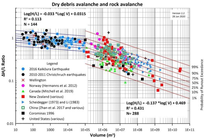
The dataset presented here is a compilation a global dataset of over 1100 back-analysed landslides from academic papers and reports where these parameters are reported. The data is available from the DesignSafe-CI site and is presented as csv. files containing information on the landslide location, reference source, volume and all available empirical runout data. The datasets are split into different landslide types, including rock avalanches, debris avalanches, debris flows, fill slope failures and mine waste failures. These datasets can be used by researchers, and geotechnical professionals to conduct forward-looking probabilistic runout analysis for different landslide types.
Head Office
1 Fairway Drive,
Avalon 5010
PO Box 30-368,
Lower Hutt 5040
New Zealand