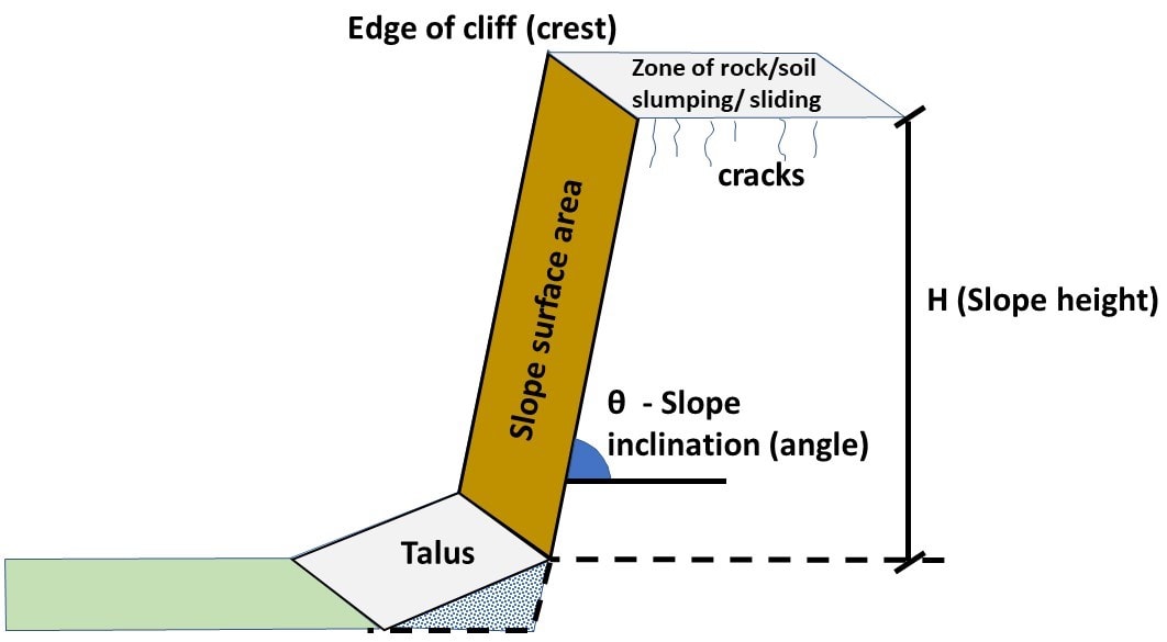
The Rockfall Activity Rate System (RoARS) provides an indication/forecast of the magnitude of rock/debris that could fall from a slope – of a given height, angle, and area – at different levels of earthquake shaking. These forecasts are derived from an empirical relationship between the volumes of rock that fell from the selected Port Hills rock slopes during the 2010/11 Canterbury Earthquake Sequence (CES), New Zealand, in response to earthquake shaking. RoARS is underpinned by the assumption that if a slope is strongly shaken by an earthquake, the volume of debris that falls from it is a function of the magnitude of the shaking (e.g., Peak Ground Acceleration) and the geometry of the slope (e.g., slope, height, and area). The method and results are presented in Massey et al. (2022) and supported by overseas work (Olsen et al. 2022a and 2022b, Holtan 2021, Olsen et al. 2020, Darrow et al. (in prep.).
The Tool is intended to be used by suitably qualified people (e.g., Professional engineering geologists and geotechnical engineers) as part of their regional-scale ‘desktop’ assessment. This Tool should not be used as a replacement or substitute for site- specific analyses and assessments.
The tool can be opened in a new window by clicking the link below, or can be used directly below in the frame.
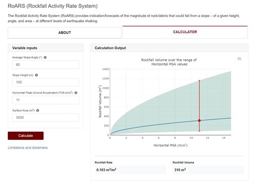
The data and model on which this Tool is based, and the creation of the tool, were prepared by the Institute of Geological & Nuclear Sciences Limited (GNS Science) as part of a New Zealand Government funded research project (MBIE Endeavour - C05X1709). The information is derived from multiple data sources, including third party data, which are at various scales and resolutions. The tool in this context is defined as the data, model and process that allows the user to forecast the volume of the material that might fall from a slope of given height, angle and area, at a given level of earthquake shaking. The algorithm (model) underpinning the tool is based on the one published in Massey et al., (2022).
As there is always uncertainty associated with the data used and the models developed from it, GNS Science gives no warranties of any kind concerning its assessment and estimates, including accuracy, completeness, timeliness or fitness for purpose, and accepts no responsibility for any actions taken based on or reliance placed on the forecasts by any person or organisation. GNS Science excludes to the full extent permitted by law any liability to any person or organisation for any loss, damage or expense, direct or indirect, and however caused, whether through negligence or otherwise, resulting from any person or organisation's use of or reliance on the Tool, the results from it and the data it is based on.
As much of the analysis and assessment relies on inferences from slopes within a particular geology and physiographical setting that were shaken by a particular suite of earthquakes, the applicability of the tool to a specific slope(s) should be considered. It is recommended that on-site verification be carried out to assess whether the tool is applicable for use at a particular site of interest.
Massey, C.I.; Olsen, M.J.; Wartman, A.; Senogles, A.; Lukovic, B.; Leshchinsky, A.; Archibald, G.C.; Litchfield, N.J.; Van Dissen, R.J.; de Vilder, S.J.; Holden, C. 2022 Rockfall activity rates before, during and after the 2010/11 Canterbury Earthquake Sequence. Journal of Geophysical Research. Earth Surface, 127(3): e2021JF006400; doi: 10.1029/2021JF006400
Olsen, Michael J., Massey, Chris, Leshchinsky, Ben, Wartman, Joseph and Senogles, Andrew. "Forecasting post-earthquake rockfall activity" Journal of Applied Geodesy, 2022. https://doi.org/10.1515/jag-2022-0045.
Olsen, M.J., Massey, C., Holtan, K.*, Wartman, J., Leshchinsky, B., Darrow, M., and Senogles, A.* (2022) Application of the rockfall activity rate system, RoARS, Extended Abstract in Proceedings of the International Society for Rock Mechanics and Rock Engineering, Eurock 2022, Helskinki, Finland.
Olsen, M.J., Massey, C., Senogles, A., Leshchinsky, B.A., and Wartman, J. (2020). Predicting seismically induced rockfall hazard for targeted site mitigation, ODOT SPR809 Final Report. https://rosap.ntl.bts.gov/view/dot/58014
Holtan, K. (2021). Assessing Seismic Rockfall Impacts on Mobility in Transportation Corridors, https://ir.library.oregonstate.edu/downloads/z316q863n
Darrow, M.M., Hermann, D.M., Holtan, K., Leshchinsky, B., Olsen, M.J., Wartman, J. (Under Review). The Long-Term Effect of Earthquakes: Using Geospatial Solutions to Evaluate Heightened Rockfall Activity on Critical Lifelines, Pactrans Final Report.
Head Office
1 Fairway Drive,
Avalon 5010
PO Box 30-368,
Lower Hutt 5040
New Zealand